Projects to be delivered under Safe Local Roads and Streets Program
Published on 25 August 2025
The Transport Accident Commission (TAC), in partnership with the Department of Transport and Planning (DTP), have developed the Safe Local Roads and Streets program for Council’s across Victoria. This is a Victorian Government initiative that has allocated Hindmarsh Shire Council $2m for the development and delivery of road safety improvement projects on local roads with a safe system approach. The program is focussed on creating a safer environment for road users including pedestrians and hence is more focussed on improving rural intersections, speed reductions, pedestrian crossings and footpaths.
In response to the opportunity, Hindmarsh Shire has worked closely with the TAC and DTP to develop safety improvement projects taking into considering past community requests and notable safety issues within the municipality. Council officers prepared a list of projects which was scrutinised by TAC and DTP against the project guideline.
Four projects have now progressed to the final application process and are listed below:
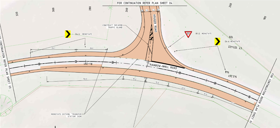
- Intersection of Nhill-Rainbow Road and Kruger Road:
This intersection is located on a high-speed dangerous curve of Nhill-Rainbow Road and is compromised with a steep blind approach. The road shoulders on this section of the road are steep and narrow, making the intersection even more dangerous.
The proposal is to improve the horizontal alignment of the road by widening the pavement and correcting elevation within the curve, and realignment of the intersection to make Kruger Road perpendicular to Nhill-Rainbow Road. The project also involves speed reduction of the road to 80KMPH on either side of the intersection. These improvements will greatly improve the safety of road users as this road carries higher volume of heavy traffic. Refer to the following image for the proposed design.
-
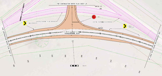
Intersection of Nhill-Rainbow Road and Solly Road:
This is another dangerous intersection located on a high-speed bend on Nhill-Rainbow Road with multiple intersections located close to it.
This project involves realignment of the intersection to make Solly Road perpendicular to Nhill-Rainbow Road, as well as decommissioning redundant legs of the intersection. The project also includes widening of the pavement and correction of elevation in the curve. Speed reduction before and after the intersection is another component of the project to improve safety. Refer to the following image for proposed design for this intersection.
-
Whitehead Avenue, Nhill
Whitehead Avenue in Nhill has multiple educational facilities as well as the town swimming pool and tennis courts, attracting significant volumes of vehicle traffic and pedestrians. Whitehead Avenue also hosts a grain handling facility that attracts greater volume of trucks, particularly during the cropping and harvest seasons. This project aims to improve the safety of pedestrians along this road, including children who walk to and from school, and from school to attend sporting activities.
This project involves construction of a concrete footpath along the north side of Whitehead Avenue through to Davis Avenue. The project also includes construction of raised pedestrian crossings in the following locations:
- Across Whitehead Avenue at the existing school crossing location.
- Across Station Street aligned with the footpath along Whitehead Avenue.
- Across Davis Avenue just to the North of the Whitehead Avenue intersection.
This project will enhance the safety of pedestrians in this area and provide a pedestrian link between Nhill College and the town centre and sports facility, while still allowing truck movements.

Raised Pedestrian Crossing across Whitehead Avenue

Raised Pedestrian Crossing across Station Street
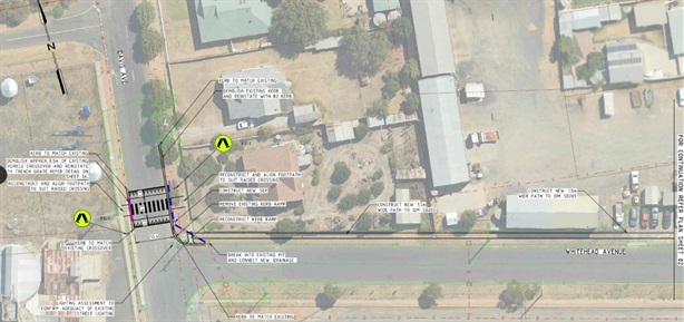
Raised Pedestrian Crossing across Davis Avenue
-
Park Street, Nhill
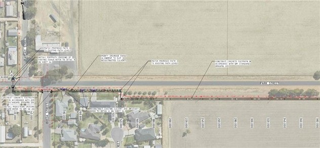
This project proposes to add a new footpath on the southern side of Park Street in Nhill. It is proposed to extend the pathway from just west of Ramsay Street (including a new crossing on Park Street), heading eastwards across Breda Street (with a new crossing) and continuing for approximately 700 metres until Queen Street, where a new crossing with kerb ramps will be installed on Queen Street.
This pathway will provide a dedicated path link for use by community members out for a walk and for students walking to and from school, particularly to the Lutheran School, and Davis Park.
85% of the travel speeds of vehicles on Park Street were observed to be 82 km/h, which is much higher than the posted speed limit of 60 km/h. This path link will increase the safety of vulnerable road users (pedestrians, cyclists, etc) by allowing them to utilise a pathway at a safer distance away from the road and traffic.
See below the draft proposal of the pathway location:

Hindmarsh Shire Council Mayor, Cr Ron Ismay said “safety of our community is high priority, and we are appreciative of the funding made available to Council for projects that would not be able to be funded through Council rates.”
Cr Ismay continued “this funding has strict criteria and can only be used for the purposes within the funding guidelines; this includes not being able to improve or undertake works on any roads that are adjacent too or junction with a VicRoads Road.”
Hindmarsh Shire Council remains committed to working with TAC and DTP to gain approval to deliver these projects that will enhance the safety and quality for all users.
For further information, please contact Ram Upadhyaya, Director Infrastructure Services on (03) 5391 4444 or email info@hindmarsh.vic.gov.au.
Monica Revell
Chief Executive Officer