Wimmera River Discovery Trail

Wimmera River Discovery Trail Logo Colour CMYK.png

Antwerp camp ground

Antwerp Camp Ground.png

Between Dimboola and Lochiel

Between Dimboola and Lochiel.png

From Ebenezer Mission Road

From Ebenezer Mission Rd.png

Leaving Swallows Hole

Leaving Swollows Hole.png

Trail and River

Trail and River.png

Wallaby along the trail

Wallaby along the trail.png

A journey along the Wimmera River Discovery Trail is more than just a hike or bike ride. It is an immersion into a timeless landscape where you will experience the beautiful, peaceful nature of the Wimmera River environment and appreciate the importance of the river to the Traditional Owners. The river provides an oasis as it weaves itself through the often harsh, hot countryside.

The trail connects Dimboola to Jeparit. Its total distance of fifty-six kilometres is suitable for walking or cycling (mountain bikes recommended). There are numerous road access points along the way so it can be enjoyed in sections. Even a short walk or ride from a road crossing will give you a good taste of what the trail has to offer.

NOTE: The entire length of the Wimmera River Discovery Trail runs along the East side of the river. Do NOT cross the river at any point.

Download Wimmera River Discovery Trail brochure/user guide(PDF, 3MB)

Section 1: Dimboola to Lochiel

Section 1: Dimboola to Lochiel 7.04km

Section 1 of the trail commences at the trail head located at the rear of the Dimboola Library. It utilises the existing Dimboola Common walking trails before crossing a deep gully at the northern end of the Common and following a vehicle track to Swallows Hole.

From Swallows Hole a new section of gravel track crosses private farming land. Please respect the use of this private land and be aware that it is a working farm. Stick to the trail at all times.

Following well formed vehicle tracks the trail leads to a side channel of the Wimmera River. This usually dry channel enables you to safely pass under the Western Highway to the trail head at Lochiel.

IMPORTANT NOTE: At times of high river levels or heavy local rain events the underpass under the Western Highway can be impassible. During these times it is strongly recommended to begin your journey along the trail at Lochiel (section 2).

Dimboola to Lochiel map 2.jpg

Section 2: Lochiel to Wundersitz Crossing

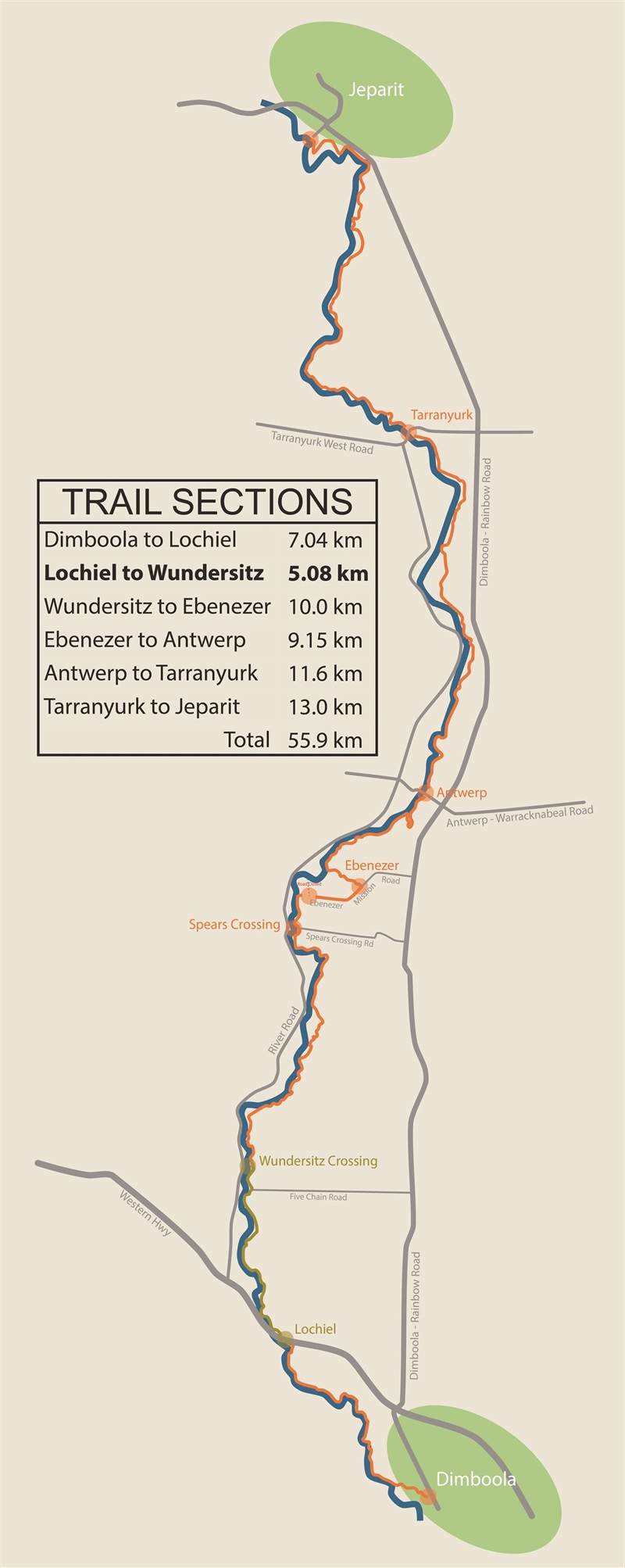
Section 2: Lochiel to Wundersitz 5.08 km

Section 2 of the trail commences at the trail head located at the north-west end of the Lochiel rest area. This is the alternative starting point for the trail if the Western Highway underpass is impassible due to water levels.

This section of the trail follows an existing vehicle trail of mostly clay soils with a few small sand patches. Easy to navigate and easy to walk or ride, this section is an enjoyable journey through floodplain woodlands dominated by Black Box and River Redgums. 

Care needs to be taken crossing sandy gullies of side creeks, and clay sections can become very boggy after rain.

Approximately 1km from the trail head the trail passes under the Adelaide to Melbourne railway line affording nice views of the river and rail bridge to the left of the track.

Five Chain Road (gravel) enters from the right around 4km from the trail head an offers an easy pickup point accessed from the Dimboola-Rainbow Road. The Wundersitz Crossing trail head can be accessed from River Road.

Lochiel to Wundersitz map 2.jpg


Section 3: Wundersitz Crossing to Ebenezer Mission Road

Section 3: Wundersitz to Ebenezer 10 km

Section 3 of the trail commences at the trail head located at Wundersitz Crossing. It follows a well-formed vehicle track north through scenic eucalypt woodlands along the river corridor.

This section of the trail is probably the easiest to walk and ride with the track being well formed and easy to navigate. There are less clay and sandy sections, and less gully crossings than in the previous trail section.

Spears Crossing Road (dirt) gives access to the Dimboola Rainbow Road, however 1km further leads to the trail head at Ebenezer and the bitumen Ebenezer Mission Road. 

IMPORTANT NOTE: Ebenezer Mission is closed to the public. Continue straight (east) along Ebenezer Mission Road for 1.5km to the next trail head. DO NOT turn left down the closed road leading to the Mission.

Wundersitz to Ebenezer map 2.jpg


Section 4: Ebenezer Mission Road to Antwerp

Section 4: Ebenezer Mission Road to Antwerp 9.15 km

Section 4 of the trail exits the Ebenezer Mission Road and heads along an anabranch back to the Wimmera River. The trail crosses the anabranch at a high point, but this may be impassable during times of high rainfall and flood. Please take care to remain on the trail through this significant Cultural and Environmental area.

Nearing Antwerp, care must be taken to follow directional guide-posts as the trail turns sharply to the right to allow crossing of a deep and long gully before returning back to the river.

A small camping area with 3 tent platforms, picnic shelter, fire-pit and toilet can be found at Antwerp.

Antwerp Camp Ground.png

 This marks the half-way point of the trail.

Ebenezer to Antwerp map 4.jpg

Section 5: Antwerp to Tarranyurk

Section 5: Antwerp to Tarranyurk 11.6 km

Section 5 of the trail continues north from Antwerp where there is a mid-way camping area.

Not far out of Antwerp you will pass a ruin of a limestone hut and boiler that are remnants of a eucalyptus oil distillery. From the late 1880s there were a number of distilleries along the Wimmera River extracting eucalyptus oil for medical, industrial and perfumery uses.

There are two challenging gullies to cross in this section that will require dismounting from bicycles and taking care. The first is approx. 1.2 km from Antwerp and then next is approx. 2.8km from Antwerp.

Between these gullies are the remains of the Old Antwerp Weir. The weir is the only man made structure on the river between the Antwerp and Tarranyurk road bridges. Constructed of timber and stone, it was built in 1903 to create a more permanent body of water for the local community. The weir pool became the venue for the annual Antwerp rowing regattas in the following years.

Antwerp to Tarranyurk map 2.jpg

Section 6: Tarranyurk to Jeparit

Section 6: Tarranyurk to Jeparit 13 km

Section 6 of the trail sees a change in the riverine environment as the river heads closer to Jeparit and Lake Hindmarsh.

The often dense Mallee scrub opens up as you near Jeparit and many of the steep riverbanks become more exposed and increase in height.

The trail emerges onto the Dimboola-Rainbow Rd and care should be taken around traffic slowing down as they enter the town.

Leaving the road just prior to the Wimmera Mallee Pioneer Museum, follow the scenic Edward Eyre Heritage River Walk. The trail winds along a maze of tributaries and islands as it makes its way through the Jeparit township.

The Wimmera River Discovery Trail ends (or starts if wanting to travel south along it) at the Jeparit River Precinct adjacent to the Jeparit Holiday Park. A picnic area with electric BBQ and toilets makes this a great place to sit, relax and reflect on the journey you have just completed.

Tarranyurk to Jeparit map 2.jpg


alt entire route Dimboola_001.jpg